A DENSE matrix of government bureaucracies currently stands like the mythological Sphinx, slowing any real action on the Myall River mouth.
In light of a recent series of stories on the Myall River and Jimmys Beach environmental situations, News Of The Area has attempted the mammoth task of unravelling the dense matrix of government bureaucracies involved.
 Advertise with News of The Area today.
It’s worth it for your business.
Message us.
Phone us – (02) 4981 8882.
Email us – media@newsofthearea.com.au
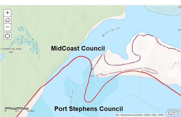
Two local councils, MidCoast and Port Stephens, share a zig-zag border along Jimmys Beach, which actually bisects the contentious eastern Natural Channel of the Myall River mouth, as the Office of Local Government website confirms.
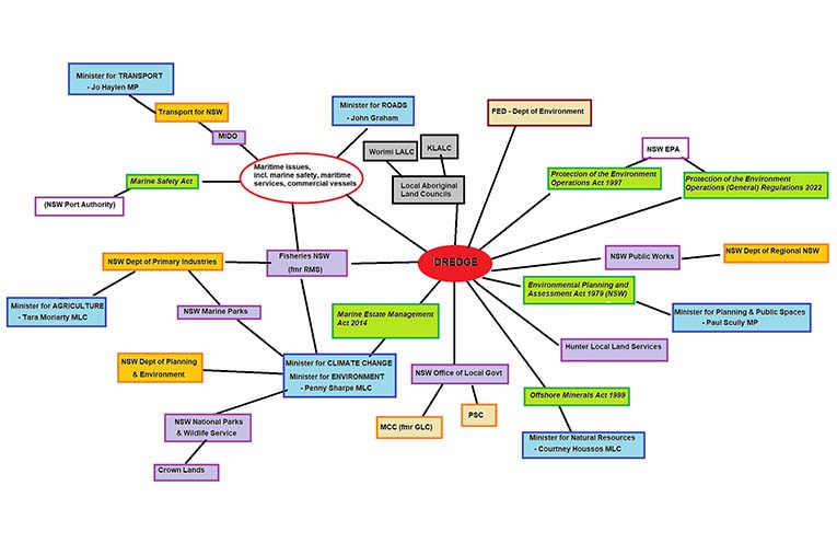
Eight state government offices, as well as two ‘independent’ (but government-funded) licensing bodies are involved: the Marine Infrastructure Delivery Office (MIDO), Fisheries, Marine Parks, National Parks & Wildlife Service, Crown Lands, Office of Local Government (OLG), Hunter Local Land Services, Public Works, the NSW Environmental Protection Agency, and the Port Authority.
Six pieces of State legislation require licensing or approvals: Marine Safety Act 1998; Marine Estate Management Act 2014; Protection of the Environment Operations Act 1997; Protection of the Environment Operations (General) Regulations 2022; Environmental Planning and Assessment Act 1979; and Offshore Minerals Act 1999.
Six State Ministers’ offices are connected with one or many of those approvals, being offices of the Ministers for: Transport; Roads; Agriculture; Natural Resources; Planning & Public Spaces; Climate Change, Environment (the last two happen to be the same person, at the moment).
Citizens should bear in mind that Ministers can be reshuffled at any time, and usually change with each State election.
Four State Government Departments, which can also be reassigned, are invariably involved: Transport for NSW; Department of Primary Industries; Department of Planning & Environment, and Department of Regional NSW.
The Federal Department of Environment is watching, too, just in case.
Finally, at least two Local Aboriginal Land Councils are obvious stakeholders, Karuah and Worimi.
Needless to say, this Kafkaesque gauntlet of bureaucratic obstacles makes it a wonder the dredge was ever installed or activated in the first place.
By Thomas O’KEEFE