
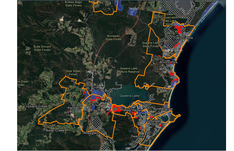
AN interactive map of the Camden Haven’s bushfire hazard zones is now available to view.
It has been developed by Port Macquarie-Hastings Council (PMHC) to help the community better understand bushfire-risk locations and the council’s role in managing them.
 Advertise with News of The Area today.
It’s worth it for your business.
Message us.
Phone us – (02) 4981 8882.
Email us – media@newsofthearea.com.au
The data is drawn from desktop analysis and on ground surveys processed through PMHC’s Bushfire Mitigation Management Tool.
The map also shows the naming conventions for the 126 Asset Protection Zones (APZ) throughout the local government area,
An APZ is an area of cleared or managed land between a dwelling and a bushfire hazard.
Keeping these areas clear provides ease-of-access for firefighters, emergency crews and maintenance personnel.
In a statement, Port Macquarie-Hastings Mayor Peta Pinson said combining this information into an easy-to-read, online interactive bushfire map will ensure greater transparency, build trust in PMHC determinations, and educate the community about bushfire mitigation.
“This is particularly important given the impacts of recent bushfires, none more devastating than the 2019 Black Summer Bushfires, which severely impacted our community,” Cr Pinson said.
The resource can be found at pmhc.nsw.gov.au/Residents/Community-support/Bushfire or by searching “bushfire” on the council’s website.
It is designed to be read in conjunction with advice on what people can do to reduce the bushfire risk in their neighbourhood and how to prepare for a high risk period.
“By showcasing the data [we have] collected and interpreting this on our online map, it provides our community with a transparent overview of our bushfire liability and [the] APZ’s requiring ongoing maintenance,” Cr Pinson said.
The map was made possible through a $635,000 grant from the Australian Government, with a co-contribution of $65,000 from PMHC.
Federal Minister for Emergency Management Murray Watt congratulated council’s work in developing the map and said mitigating against the risk of disasters is everyone’s responsibility.
“Locals armed with the right information can take steps to safeguard their homes and their neighbourhoods against bushfires.”